
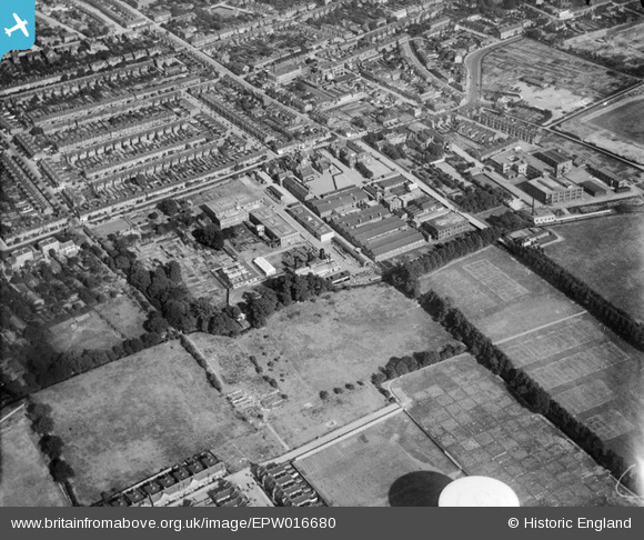
EPW016680 ENGLAND (1926). The London Electric Wire Company Works and environs, Leyton, 1926
© Hawlfraint cyfranwyr OpenStreetMap a thrwyddedwyd gan yr OpenStreetMap Foundation. 2024. Trwyddedir y gartograffeg fel CC BY-SA.
Delweddau cyfagos (28)
EPW016680

EAW030524

EPW008515

EPW016677

EAW030521

EPW016682

EPW008514

EAW030518

EPW016675

EPW016679

EAW030517

EAW030520

EPW008516

EAW030516

EPW016681

EAW030519

EPW016676

EPW008513

EPW008351

EAW030523

EAW030522

EAW030525

EPW008518

EPW016685

EPW016683

EPW016684

EPW008519

EPW008352

Manylion
| Pennawd | [EPW016680] The London Electric Wire Company Works and environs, Leyton, 1926 |
| Cyfeirnod | EPW016680 |
| Dyddiad | August-1926 |
| Dolen | |
| Enw lle | LEYTON |
| Plwyf | |
| Ardal | |
| Gwlad | ENGLAND |
| Dwyreiniad / Gogleddiad | 537056, 187107 |
| Hydred / Lledred | -0.022369720185162, 51.56568406546 |
| Cyfeirnod Grid Cenedlaethol | TQ371871 |
Pinnau
 Ross |
Tuesday 27th of October 2015 09:26:32 PM |
Cyfraniadau Grŵp
Using Image 016680 as a Base Comment (have seen comments are attached to each image in the set -distracting from other viewers interpretation!). The view has the factory centre and left with the tree line at the bottom left in an 'L' shape. Alongside to the right is Church Mead School with more factory sheds behind it. To the right again (across Marsh Lane) is the Caribonum Works behind Etloe House. In the bottom left corner is Seymour Road, so this places the current site of the Lammas School in the open field just above where the roadway stops. The white 'dome' object at the bottom centre is not part of the plane but one of the nearby gasholders at the Perth Road gasworks plant. |
 8-2007.JPG) Keith |
Saturday 30th of June 2012 01:47:28 AM |


