
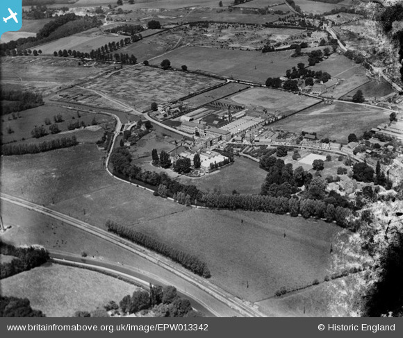
EPW013342 ENGLAND (1925). Ware Mills on the River Lea, Ware, 1925
© Hawlfraint cyfranwyr OpenStreetMap a thrwyddedwyd gan yr OpenStreetMap Foundation. 2024. Trwyddedir y gartograffeg fel CC BY-SA.
Delweddau cyfagos (6)
EPW013342

EPW025933

EPW025927

EAW022400

EAW022402

EPW025929

Manylion
| Pennawd | [EPW013342] Ware Mills on the River Lea, Ware, 1925 |
| Cyfeirnod | EPW013342 |
| Dyddiad | June-1925 |
| Dolen | |
| Enw lle | WARE |
| Plwyf | WARE |
| Ardal | |
| Gwlad | ENGLAND |
| Dwyreiniad / Gogleddiad | 535346, 214262 |
| Hydred / Lledred | -0.036494712692794, 51.810138090131 |
| Cyfeirnod Grid Cenedlaethol | TL353143 |
Pinnau
 NJL61 |
Saturday 8th of May 2021 10:21:46 PM | |
Colin |
Monday 20th of November 2017 09:37:02 AM | |
Colin |
Tuesday 31st of January 2017 04:29:33 PM | |
Colin |
Tuesday 31st of January 2017 04:27:31 PM | |
Colin |
Tuesday 31st of January 2017 02:43:36 PM | |
Colin |
Tuesday 31st of January 2017 02:39:47 PM | |
Nick G |
Sunday 20th of October 2013 08:18:11 PM | |
Nick G |
Sunday 20th of October 2013 08:17:30 PM | |
Nick G |
Sunday 20th of October 2013 08:17:01 PM | |
Nick G |
Sunday 20th of October 2013 08:16:26 PM | |
Nick G |
Sunday 20th of October 2013 08:15:44 PM | |
Nick G |
Sunday 20th of October 2013 08:15:10 PM | |
Nick G |
Sunday 20th of October 2013 08:14:37 PM | |
Nick G |
Sunday 20th of October 2013 08:14:16 PM |
Cyfraniadau Grŵp
I mean Ware (Frenlite) flour mills which were situated between Amwell End and Station Road, not the Allen & Hanbury site. |
sharpsecret |
Sunday 25th of August 2013 10:43:35 PM |
My father was mill manager of Ware Mills from 1963 until its closure in about 1988. I have many photographs of the interior of the mill if anyone is interested. |
sharpsecret |
Sunday 25th of August 2013 10:41:58 PM |


