
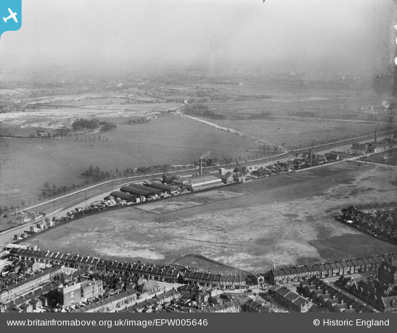
EPW005646 ENGLAND (1921). Factories and wharves alongside the Hackney Cut Navigation, Hackney Marsh, from the west, 1921
© Hawlfraint cyfranwyr OpenStreetMap a thrwyddedwyd gan yr OpenStreetMap Foundation. 2024. Trwyddedir y gartograffeg fel CC BY-SA.
Delweddau cyfagos (3)
EPW005646

EPW005648

EPW005647

Manylion
| Pennawd | [EPW005646] Factories and wharves alongside the Hackney Cut Navigation, Hackney Marsh, from the west, 1921 |
| Cyfeirnod | EPW005646 |
| Dyddiad | March-1921 |
| Dolen | |
| Enw lle | HACKNEY MARSH |
| Plwyf | |
| Ardal | |
| Gwlad | ENGLAND |
| Dwyreiniad / Gogleddiad | 536265, 185712 |
| Hydred / Lledred | -0.034316859236516, 51.553338760654 |
| Cyfeirnod Grid Cenedlaethol | TQ363857 |
Pinnau
 Dank |
Monday 23rd of November 2020 09:25:28 AM | |
hackneyglyn |
Thursday 31st of December 2015 09:52:53 AM | |
hackneyglyn |
Thursday 31st of December 2015 09:19:04 AM | |
 |
hackneyglyn |
Thursday 31st of December 2015 09:15:15 AM |
FandF |
Monday 30th of December 2013 10:59:04 PM | |
 8-2007.JPG) Keith |
Friday 16th of November 2012 12:18:09 AM | |
Keith |
Friday 16th of November 2012 12:13:53 AM | |
Definately now Lea Interchange, but the Lea was at least up to the Olympics, tidal up to The Prince of Wales, just below Lea Bridge Road. |
hackneyglyn |
Wednesday 30th of December 2015 10:56:21 PM |
Keith |
Friday 16th of November 2012 12:12:38 AM | |
Keith |
Friday 16th of November 2012 12:11:23 AM |
Cyfraniadau Grŵp
 I think the highest point at which the Old River Lee was tidal would have been at Lee Bridge where the sluices still allow a controlled water flow from the Lee Navigation into the Old River Lee. |
Martin Slavin |
Wednesday 30th of December 2015 10:58:48 PM |
Unfortunately this is not borne out by reference to any survey published on an O.S. map. |
Keith |
Thursday 8th of August 2013 10:14:38 PM |
Hi Martin! Yes you are right. |
hackneyglyn |
Wednesday 30th of December 2015 10:57:13 PM |
Hi Keith for years I worked on Hackney Marshes, up to c2010, and clearly saw the tide coming up, past the Marshes and to the sluice below the Lea Bridge Road |
hackneyglyn |
Wednesday 30th of December 2015 10:58:48 PM |


