
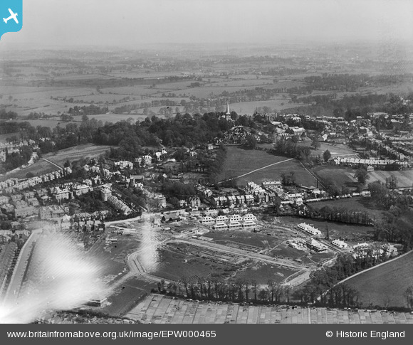
EPW000465 ENGLAND (1920). Harrow on the Hill, from the north-west, 1920
© Hawlfraint cyfranwyr OpenStreetMap a thrwyddedwyd gan yr OpenStreetMap Foundation. 2024. Trwyddedir y gartograffeg fel CC BY-SA.
Delweddau cyfagos (5)
EPW000465

EPW005345

EAW028794

EPW005448A

EPW000470

Manylion
| Pennawd | [EPW000465] Harrow on the Hill, from the north-west, 1920 |
| Cyfeirnod | EPW000465 |
| Dyddiad | April-1920 |
| Dolen | |
| Enw lle | HARROW ON THE HILL |
| Plwyf | |
| Ardal | |
| Gwlad | ENGLAND |
| Dwyreiniad / Gogleddiad | 514859, 187714 |
| Hydred / Lledred | -0.34230151946587, 51.576099467791 |
| Cyfeirnod Grid Cenedlaethol | TQ149877 |
Pinnau
 The Laird |
Thursday 20th of February 2020 12:39:28 PM | |
The Laird |
Sunday 12th of January 2020 11:50:02 AM | |
The Laird |
Sunday 12th of January 2020 11:47:44 AM | |
The Laird |
Sunday 12th of January 2020 11:46:01 AM | |
The Laird |
Sunday 12th of January 2020 11:43:01 AM | |
The Laird |
Sunday 12th of January 2020 11:00:12 AM | |
The Laird |
Sunday 12th of January 2020 10:40:27 AM | |
The Laird |
Wednesday 6th of January 2016 02:11:14 PM | |
The Laird |
Wednesday 6th of January 2016 02:09:22 PM | |
JamesMac |
Wednesday 28th of August 2013 03:50:42 PM | |
JamesMac |
Wednesday 28th of August 2013 03:49:46 PM |


