
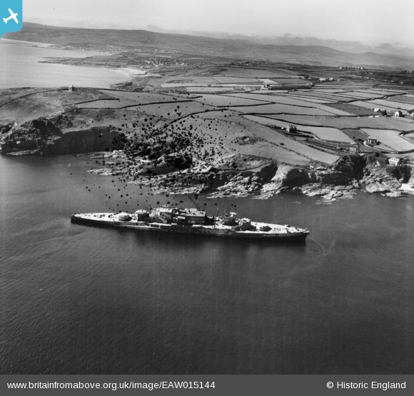
EAW015144 ENGLAND (1948). HMS Warspite aground off Prussia Cove, Prussia Cove, from the south-east, 1948. This image has been produced from a damaged negative.
© Hawlfraint cyfranwyr OpenStreetMap a thrwyddedwyd gan yr OpenStreetMap Foundation. 2024. Trwyddedir y gartograffeg fel CC BY-SA.
Delweddau cyfagos (4)
EAW015144

EAW005977

EAW005979

EAW005978

Manylion
| Pennawd | [EAW015144] HMS Warspite aground off Prussia Cove, Prussia Cove, from the south-east, 1948. This image has been produced from a damaged negative. |
| Cyfeirnod | EAW015144 |
| Dyddiad | 29-April-1948 |
| Dolen | |
| Enw lle | PRUSSIA COVE |
| Plwyf | ST. HILARY |
| Ardal | |
| Gwlad | ENGLAND |
| Dwyreiniad / Gogleddiad | 155616, 27717 |
| Hydred / Lledred | -5.4176648706261, 50.098555677664 |
| Cyfeirnod Grid Cenedlaethol | SW556277 |
Pinnau
 dave43 |
Friday 20th of July 2018 09:43:01 PM | |
dave43 |
Friday 20th of July 2018 09:41:25 PM | |
dave43 |
Friday 20th of July 2018 09:39:35 PM | |
dave43 |
Friday 20th of July 2018 09:36:52 PM | |
dave43 |
Friday 20th of June 2014 08:09:28 PM | |
dave43 |
Friday 20th of June 2014 08:02:18 PM | |
dave43 |
Thursday 30th of January 2014 07:49:39 PM | |
dave43 |
Thursday 30th of January 2014 07:47:20 PM |
Cyfraniadau Grŵp
Warspite had been aground here since April 1947 when she had been on her way to Faslane for breaking up. She eventually left in 1950 and was slowly broken up near Penzance. |
mannidaze |
Friday 12th of September 2014 05:08:12 PM |
The battleship appears partially stripped. Guns have gone from their turrets and part of the superstructure has been removed |
MB |
Sunday 9th of March 2014 09:01:27 PM |
yes, it was difficult getting the scrap up the narrow roads, it was refloated I think with the idea of getting it to Wales but it only got as far as Marazion where it was finally broken up |
dave43 |
Sunday 9th of March 2014 09:01:27 PM |


