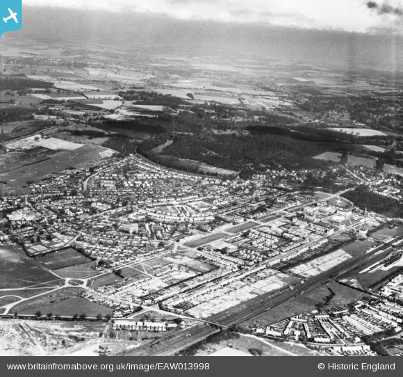
EAW013998 ENGLAND (1948). The town, Welwyn Garden City, from the south-east, 1948
© Hawlfraint cyfranwyr OpenStreetMap a thrwyddedwyd gan yr OpenStreetMap Foundation. 2024. Trwyddedir y gartograffeg fel CC BY-SA.
Delweddau cyfagos (14)
Manylion
| Pennawd | [EAW013998] The town, Welwyn Garden City, from the south-east, 1948 |
| Cyfeirnod | EAW013998 |
| Dyddiad | 23-March-1948 |
| Dolen | |
| Enw lle | WELWYN GARDEN CITY |
| Plwyf | |
| Ardal | |
| Gwlad | ENGLAND |
| Dwyreiniad / Gogleddiad | 523498, 212578 |
| Hydred / Lledred | -0.2088823139733, 51.797746505558 |
| Cyfeirnod Grid Cenedlaethol | TL235126 |
Pinnau
 Richard Armstrong |
Sunday 10th of November 2019 11:30:18 PM | |
 Chells809 |
Thursday 27th of February 2014 11:59:18 AM | |
 Chells809 |
Thursday 27th of February 2014 11:58:12 AM | |
 Chells809 |
Thursday 27th of February 2014 11:57:15 AM | |
 Chells809 |
Thursday 27th of February 2014 11:56:07 AM | |
 Chells809 |
Thursday 27th of February 2014 11:53:54 AM | |
 Chells809 |
Thursday 27th of February 2014 11:52:36 AM |


![[EAW013998] The town, Welwyn Garden City, from the south-east, 1948](http://britainfromabove.org.uk/sites/all/libraries/aerofilms-images/public/100x100/EAW/013/EAW013998.jpg)
![[EPW054510] St Bonaventure Roman Catholic Church and School alongside Parkway, Handside, 1937](http://britainfromabove.org.uk/sites/all/libraries/aerofilms-images/public/100x100/EPW/054/EPW054510.jpg)
![[EPW062076] The town, Welwyn Garden City, 1939. This image has been affected by flare.](http://britainfromabove.org.uk/sites/all/libraries/aerofilms-images/public/100x100/EPW/062/EPW062076.jpg)
![[EAW013993] Parkway and the surrounding town, Welwyn Garden City, 1948](http://britainfromabove.org.uk/sites/all/libraries/aerofilms-images/public/100x100/EAW/013/EAW013993.jpg)
![[EPW054514] The residential area surrounding Lytton Gardens, Birdcroft Road and Longcroft Lane, Handside, 1937](http://britainfromabove.org.uk/sites/all/libraries/aerofilms-images/public/100x100/EPW/054/EPW054514.jpg)
![[EPW054538] The residential area surrounding Lytton Gardens and Parkfields, Handside, 1937. This image has been affected by flare.](http://britainfromabove.org.uk/sites/all/libraries/aerofilms-images/public/100x100/EPW/054/EPW054538.jpg)
![[EPW054509] Old Parkway School, Handside, 1937](http://britainfromabove.org.uk/sites/all/libraries/aerofilms-images/public/100x100/EPW/054/EPW054509.jpg)
![[EPW054534] The residential area surrounding Lytton Gardens and Parkfields, Handside, 1937](http://britainfromabove.org.uk/sites/all/libraries/aerofilms-images/public/100x100/EPW/054/EPW054534.jpg)
![[EPW062075] The town, Welwyn Garden City, 1939](http://britainfromabove.org.uk/sites/all/libraries/aerofilms-images/public/100x100/EPW/062/EPW062075.jpg)
![[EPW047377] Handside and Sharrardspark Wood, Welwyn Garden City, 1935](http://britainfromabove.org.uk/sites/all/libraries/aerofilms-images/public/100x100/EPW/047/EPW047377.jpg)
![[EPW022017] The Cottage and the Ebenezer Howard Memorial, Welwyn Garden City, 1928](http://britainfromabove.org.uk/sites/all/libraries/aerofilms-images/public/100x100/EPW/022/EPW022017.jpg)
![[EPW047376] Handside, Welwyn Garden City, 1935](http://britainfromabove.org.uk/sites/all/libraries/aerofilms-images/public/100x100/EPW/047/EPW047376.jpg)
![[EPW054531] The residential area at Handside, Welwyn Garden City, 1937](http://britainfromabove.org.uk/sites/all/libraries/aerofilms-images/public/100x100/EPW/054/EPW054531.jpg)
![[EPW009817] Queens Road and Lower Handside Farm, Welwyn Garden City, from the south, 1924](http://britainfromabove.org.uk/sites/all/libraries/aerofilms-images/public/100x100/EPW/009/EPW009817.jpg)


