
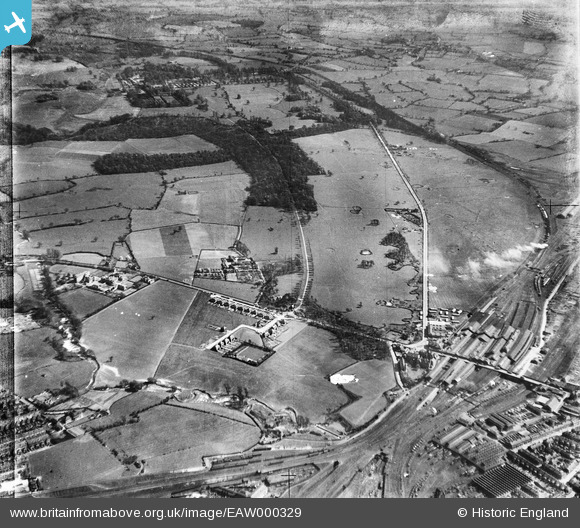
EAW000329 ENGLAND (1946). Crewe Railway Station, Crewe Park and surrounding countryside, Crewe, from the north-west, 1946
© Hawlfraint cyfranwyr OpenStreetMap a thrwyddedwyd gan yr OpenStreetMap Foundation. 2024. Trwyddedir y gartograffeg fel CC BY-SA.
Manylion
| Pennawd | [EAW000329] Crewe Railway Station, Crewe Park and surrounding countryside, Crewe, from the north-west, 1946 |
| Cyfeirnod | EAW000329 |
| Dyddiad | 19-April-1946 |
| Dolen | |
| Enw lle | CREWE |
| Plwyf | |
| Ardal | |
| Gwlad | ENGLAND |
| Dwyreiniad / Gogleddiad | 371388, 354950 |
| Hydred / Lledred | -2.4272805250069, 53.090695806895 |
| Cyfeirnod Grid Cenedlaethol | SJ714550 |
Pinnau
 SteveB |
Thursday 6th of April 2023 11:27:10 AM | |
Sparky |
Saturday 4th of November 2017 12:23:49 PM | |
Crewedaddy |
Wednesday 13th of September 2017 01:03:59 AM | |
Sparky |
Friday 1st of September 2017 04:25:51 PM | |
they appear on the 1910 Ordnance Survey map! https://www.old-maps.co.uk/#/Map/370500/355500/12/101234 |
SteveB |
Sunday 4th of October 2020 05:08:49 PM |
JCC |
Saturday 24th of August 2013 10:57:19 PM | |
SteveB |
Friday 23rd of August 2013 06:15:52 PM | |
SteveB |
Friday 23rd of August 2013 06:07:58 PM | |
SteveB |
Friday 23rd of August 2013 06:06:39 PM | |
SteveB |
Friday 23rd of August 2013 06:05:41 PM | |
SteveB |
Friday 23rd of August 2013 05:43:58 PM | |
SteveB |
Friday 23rd of August 2013 05:39:32 PM | |
SteveB |
Friday 23rd of August 2013 05:37:50 PM | |
SteveB |
Friday 23rd of August 2013 05:37:07 PM | |
SteveB |
Friday 23rd of August 2013 05:33:51 PM |


